


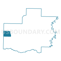
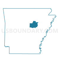
Marshall Voting District, White County, Arkansas
About
Outline

Summary
| Unique Area Identifier | 528465 |
| Name | Marshall Voting District |
| County | White County |
| State | Arkansas |
| Area (square miles) | 23.42 |
| Land Area (square miles) | 23.40 |
| Water Area (square miles) | 0.02 |
| % of Land Area | 99.90 |
| % of Water Area | 0.10 |
| Latitude of the Internal Point | 35.24115580 |
| Longtitude of the Internal Point | -92.06391250 |
Maps

Graphs
Select a template below for downloading or customizing gragh for Marshall Voting District, White County, Arkansas


Neighbors
Neighoring Voting District (by Name) Neighboring Voting District on the Map
- Coffey Voting District, White County, AR
- Gravel Hill Voting District, White County, AR
- Jefferson Voting District, White County, AR
- Kentucky Voting District, White County, AR
- Mountain Voting District, Faulkner County, AR
- Mt Vernon Voting District, Faulkner County, AR
Top 10 Neighboring County Subdivision (by Population) Neighboring County Subdivision on the Map
- Kentucky township, White County, AR (1,328)
- Coffey township, White County, AR (1,196)
- Marshall township, White County, AR (910)
- Jefferson township, White County, AR (507)
- Mount Vernon township, Faulkner County, AR (503)
- Gravel Hill township, White County, AR (389)
- Mountain township, Faulkner County, AR (363)
Top 10 Neighboring Place (by Population) Neighboring Place on the Map
Top 10 Neighboring Unified School District (by Population) Neighboring Unified School District on the Map
- Beebe School District, AR (17,431)
- Rose Bud School District, AR (4,633)
- Mount Vernon-Enola School District, AR (2,964)
Top 10 Neighboring State Legislative District Lower Chamber (by Population) Neighboring State Legislative District Lower Chamber on the Map
- State House District 47, AR (34,367)
- State House District 49, AR (32,244)
- State House District 59, AR (29,163)
Top 10 Neighboring State Legislative District Upper Chamber (by Population) Neighboring State Legislative District Upper Chamber on the Map
- State Senate District 30, AR (103,943)
- State Senate District 18, AR (85,656)
- State Senate District 29, AR (85,160)
- State Senate District 12, AR (83,956)
Top 10 Neighboring 111th Congressional District (by Population) Neighboring 111th Congressional District on the Map
Top 10 Neighboring Census Tract (by Population) Neighboring Census Tract on the Map
- Census Tract 710, White County, AR (7,016)
- Census Tract 302, Faulkner County, AR (6,052)
- Census Tract 703, White County, AR (5,287)